Uttarkashi flash flood: ISRO map shows Dharali barely exists now; river course changed, debris covers 20 hectares | Dehradun News

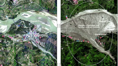
DEHRADUN: A high-magnitude flash flood damaged multiple buildings, altered river paths, and left behind a 20-hectare debris field in Uttarkashi’s Dharali and Harsil villages on Aug 5, satellite images released by the Indian Space Research Organisation (Isro) on Thursday revealed. The National Remote Sensing Centre (NRSC), a wing of Isro, used imagery from the Cartosat-2S satellite to assess the scale of destruction. The post-event image, from Thursday, was compared with pre-event data from June 2024. It showed a fan-shaped debris spread measuring approximately 750m by 450m at the confluence of the Kheer Gad and Bhagirathi rivers.Isro said the flood had significantly widened stream channels and altered river morphology, considered typical indicators of flash flood events. It also confirmed that several buildings in Dharali had either been swept away or buried. Isro said that a scientific analysis is underway to determine the cause of the flood. It added that the event highlights the increasing vulnerability of Himalayan settlements. Gaurav Talwar


